
In this summer of continuing extreme weather and devastating impacts, Canada has been particularly hard hit.
As of Sunday, July 16, 881 wildfires were blazing there, according to data from the Canadian Interagency Forest Fire Centre. Since the start of the year, 4,157 fires have burned across nearly 39,000 square miles of land — an area slightly bigger than the State of Maine.
That tally of torching — the result of a continuing combination of unusual heat, drought, and dry lightning — has already blown away the record for most land burned in a year in Canada. It's also about 4.5 times the annual average of land burned there between 1983 and 2022 — and much of the wildfire season is still yet to come.
Remote Sensing Provides a Dramatic Perspective
Satellites have been providing both broad-scale and close-up views of the fires, driving home both their scope and ferocity. The image at the top of this story, and the ones that follow, offer a sampling.
This image reveals the scope of wildfire activity in British Columbia. Nearly 5,000 square miles have been scorched in the province since January 1. That's roughly 30 times the average for this point in the year, according to NASA.
Nearly 400 new wildfires ignited in British Columbia last week alone. About half stemmed from intense thunderstorm activity, which zapped the province with some 51,000 lightning strikes.
Pulling back for a broader view, smothering rivers of smoke from Canadian wildfires are clearly visible from coast-to-coast in this image acquired by the NOAA-20 satellite on July 15. The smoke appears in tones of gray and tan, as distinct from clouds, which appear bright white. Red dots mark areas where satellite sensors detected anomalous heat indicative of fire.
As of Monday, July 17, more than 4 million Canadians and 70 million Americans were suffering from unhealthy air due to the smoke.
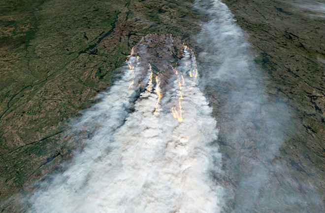
A wildfire blazing near Waskaganish in Canada's Quebec province is seen in this satellite image. Waskaganish is a Cree village of about 2,000 people at the mouth of the Rupert River on the southeast shore of James Bay. (Waskaganish means "Little House" in the Cree language.)
About 5,800 square miles of Quebec have been scorched so far this year. That's more than 100 times greater than average for this time of year.
Assessing the Role of Climate Change
How big a factor has climate change played in individual wildfire outbreaks in Canada? A definitive answer will have to await the conclusion of so-called "attribution" studies. But here are some things that are known:
When looking at the historical record, the large number of fires and the sheer amount of acreage burned has been very unusual. Also noteworthy is the widespread nature of the blazes.
"The distribution of fires from coast to coast this year is unusual," said Michael Norton, with Canada's Natural Resources ministry, quoted by Reuters back in early June — even before the most recent upsurge in wildfires scorching British Columbia. "At this time of the year, fires usually occur only on one side of the country at a time, most often that being in the west."
One factor tying together the coast-to-coast wildfire events in Canada is unusually warm and dry conditions. And during at least one previous extreme Canadian wildfire season, scientists found that such conditions were made much more likely by human-caused climate change.
It happened in British Columbia during 2017, when 4,633 square miles burned. An attribution analysis revealed that human-induced climate change contributed greatly to the probability of the extremely warm temperatures, the high risk for wildfires, and the very large amount of land that was burned.
"This profound influence of climate change on forest fire extremes in British Columbia, which is likely reflected in other regions and expected to intensify in the future, will require increasing attention in forest management, public health, and infrastructure," the study authors wrote in their paper.
Attribution research that's still to come will give us greater clarity about what's happening right now. But there doesn't appear to be a reason why the current situation should be different.
Research also has found clear connections between climate change and wildfires in the United States. For example, the most recent U.S. National Climate Assessment, published in 2018, found that fire seasons have been lengthening throughout the western United States as temperatures have risen and mountain snowpack has melted out earlier.
Similarly, a 2020 study found that the amount of land that burned at "high severity" between 1985 and 2017 had increased across most forests in the western United States, coincident with warmer and drier fire seasons.


